Menu

An overview of the vast surroundings is of strategic importance

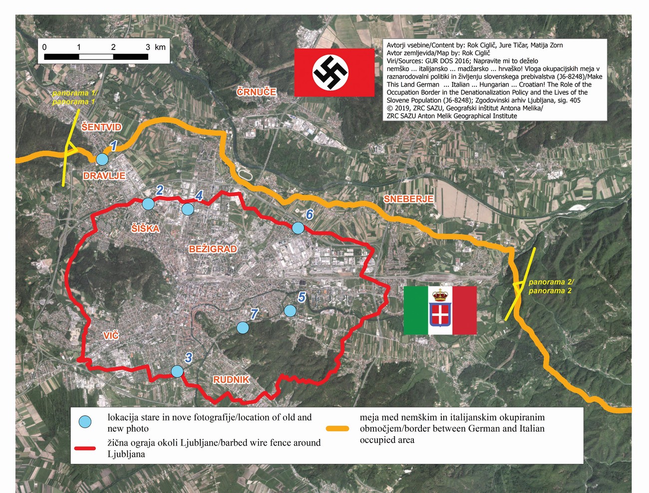
The guard towers were used by the occupying forces during World War II to facilitate the control of the wider area. Where the delimitation between the Italian and German occupation areas took place in the hilly terrain, the top of ridges were generally controlled by the Germans. Thus, the border was at the expense of the Italians under the ridges. This enabled Germans to place their guard towers on the ridge of the Kašelj Hill east of Ljubljana, as well as on the ridge between Šentvid and Toško Čelo northwest of Ljubljana, under which the Šentvid Tunnel is underway today. With this, the Germans had a broad view of the southern Ljubljana Basin and could control the Italian occupation of Ljubljana, especially its central and northern parts.

The map shows the stands with the field of visual of both panoramas and the photo stands 1 first panorama and photo stand 2 second panorama.


Panorama 1. The panoramic view from the top of Mala Trata to the west of Šentvid covers the field of vision between 190° (south; southern gate into the Šentvid Tunnel; in the background is Mount Krim) and 10° (north; northern gate into the Šentvid Tunnel; in the background are the Kamnik-Savinja Alps). Most of today's urbanized area of Ljubljana was under Italy, as the border was located south of the Sava River. From this position, the Germans easily controlled a large part of the Italian territory. Panorama is made on the basis of satellite imagery in the Google Earth web globe. The red line indicates the course of the barbed wire around Ljubljana.


Panorama 2. The panoramic view from the top of Deben vrh on the Kašelj Hill covers the field of vision between 210° (southwest; Sostro, in the background are Golovec Hill and Mount Krim) and 30° (northeast; Dol pri Ljubljani; in the background are the Kamnik-Savinja Alps). This view also allowed the Germans to control the Italian territory south of the Sava River. Panorama is made on the basis of satellite imagery in the Google Earth web globe. The red line indicates the course of the barbed wire around Ljubljana.


1: The former border crossing between Italy and Germany at today’s crossroads of Celovška cesta and Cesta Andreja Bitenca roads. The Šmarna gora Hill is visible in the background. Author: Jakob Prešern. MNZS.