The war brought on another important change for the people of Rogaška Slatina, and even more so for the inhabitants of the surrounding area in the east and southeast. After Slovene territory was carved up among the occupiers, the border between the German Third Reich and the Independent State of Croatia ran through it. The Germans and Croatians resolved their border issues regarding the exact course of the boundary by late June and the Sotla River became a boundary river. For the majority of Croatians from the Hrvatsko Zagorje region on the other side of the border, who used to migrate to the Slovene side on a daily basis to go to work, shop, see a doctor, go to church, etc., crossing the border suddenly became very difficult. The border was soon heavily guarded by the Germans; they protected it with minefields, barbed wire barriers, watchtowers, stations with machine guns, etc. In the borderland, they tore down all the buildings and thinned the forest to roughly 50 metres wide, enabling greater control of both sides of the border. This was mostly carried out with forced labour, which involved the local population. The owner was allowed to remove the felled wood and use it for his own needs; if not, it was removed by forced labourers for the needs of the Germans. They were not allowed to pile branches but had to scatter them as widely as possible across the clearing to prevent undergrowth.
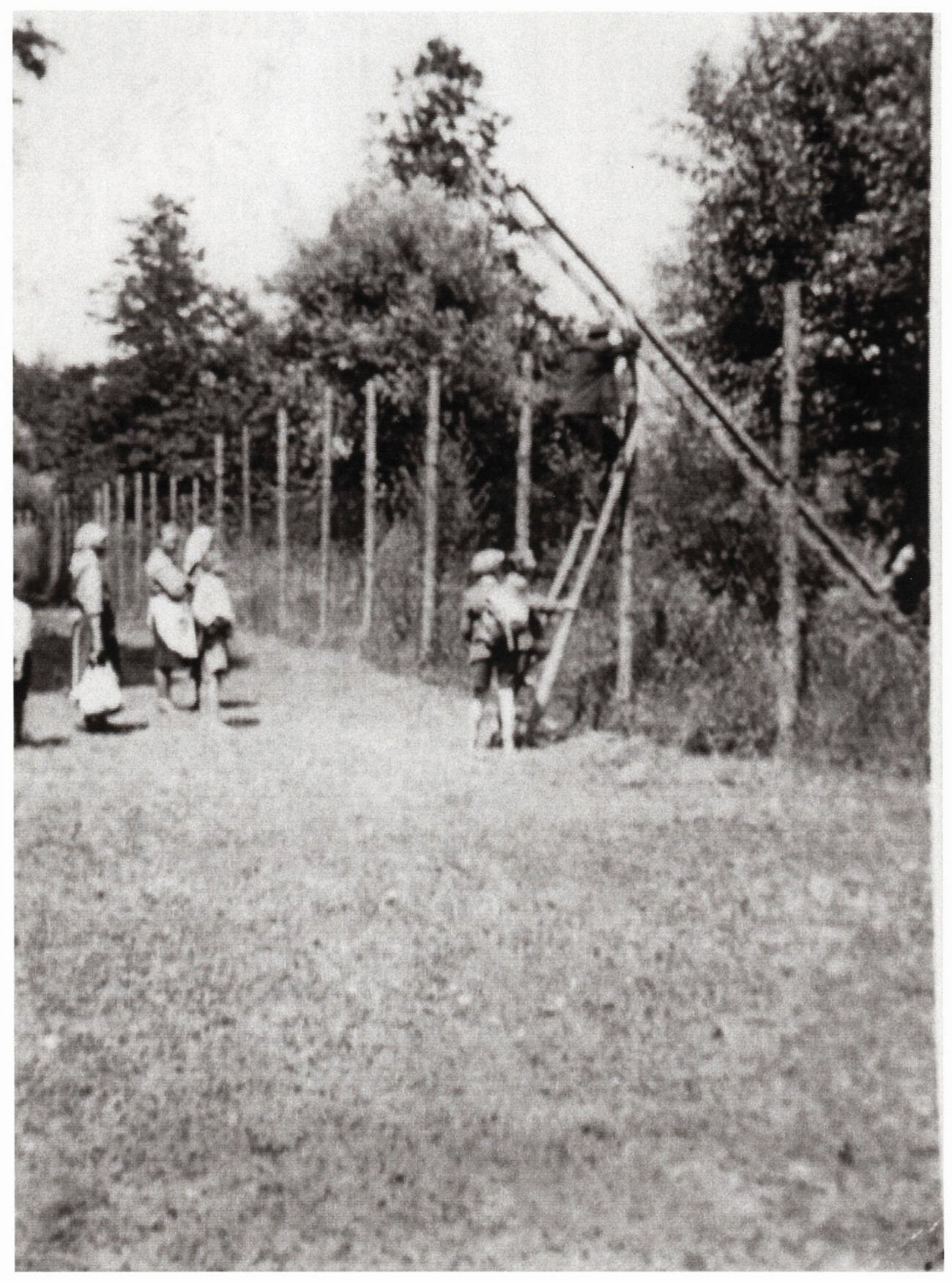
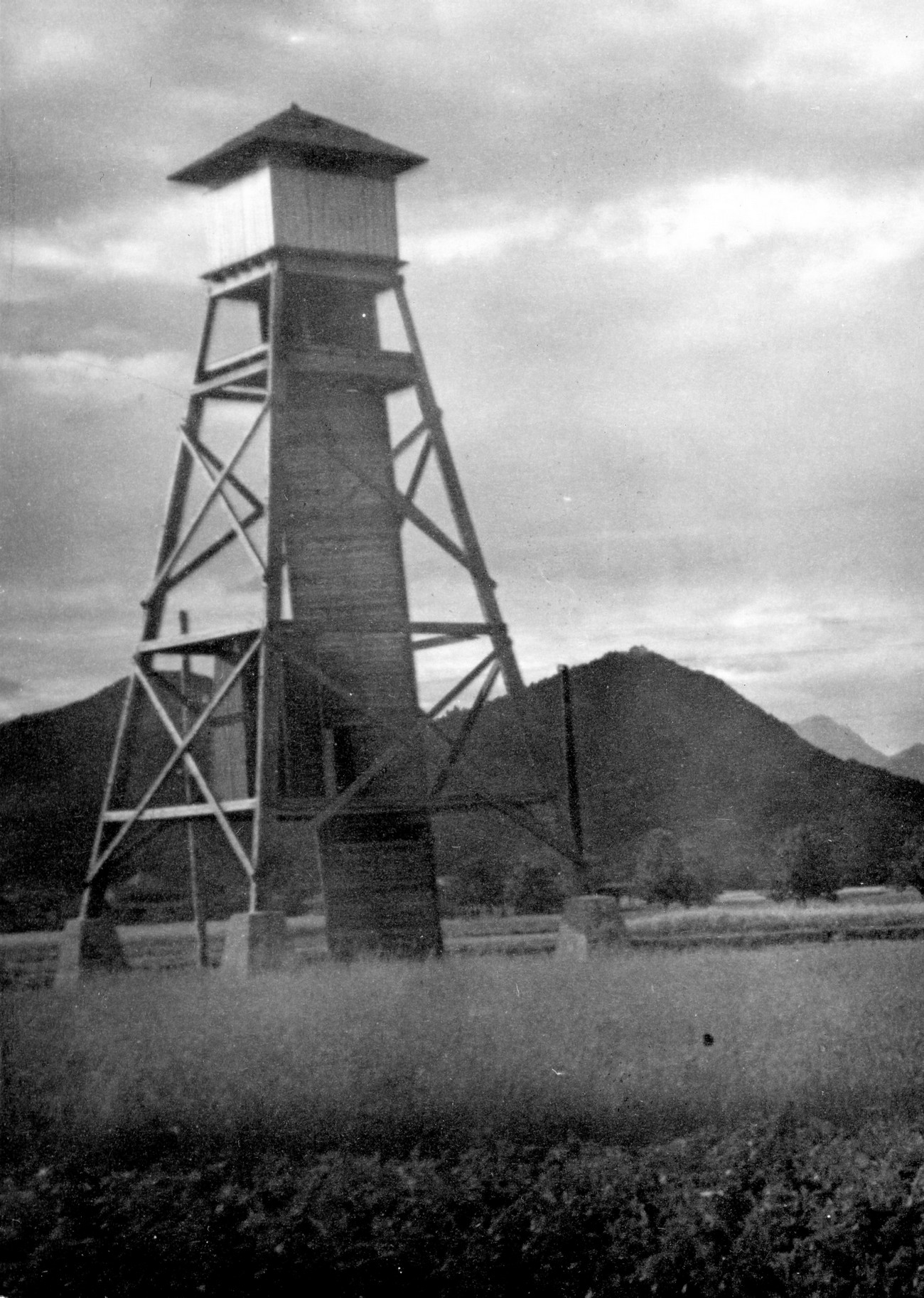
The border was regularly patrolled. A watchtower often stood next to the border, built with four load-bearing posts made from pairs of logs; at the top there was a covered guard station, measuring roughly 3x3 metres. The guard station could be accessed by a ladder or wooden stairs. Next to the tower they often built bunkers and installed telephone lines. The Germans already began to fortify the border in the vicinity of Rogaška Slatina with safeguards in the autumn of 1941.
Fatalities on the Border
Along the border – the Sotla River – the Germans erected a two-metre-high chainlink fence, which was topped with three rows of barbed wire. Behind it they placed a two- to three-metre-wide strip of barbed tape, followed by landmines a few metres apart. The landmines were placed by the army while the rest of the work was done by conscripts. Three types of mines were used: 1) the so-called sifonarice, which were primarily meant to scare; they were placed ten metres from the wire; 2) black mines, with a serrated edge and much more dangerous, were placed right next to the border; 3) the most dangerous landmines were activated by the pressure of around 30kg.
Mines were the greatest threat to the local population. They hindered or even prevented the people from crossing over to the fields and forests, and it took them much longer to get to the shop, doctor or church. Livestock could no longer graze in the borderland because landmines were often detonated and animals died when they reached beyond the wire. Animals were not the only landmine casualties – so were people.
According to the data known so far, there were fourteen border crossings between Germany and the NDH in the vicinity of Rogaška Slatina (from Dobovec to Podčetrtek). They were: No. 1: Furt zwischen Terlitschner und Hromec, informal name: “Terlično-Hromec”; local border traffic. No. 2: St. Rochus-Burmanec; Eisenbahnübergang (railway) for international border traffic. No. 3: Brücke bei Grenzpfahl 75, Fahrweg von Dobrowetz nach Lupinjek beim kroatischen Schulhaus; local border traffic. No. 4: St. Rochus-Lupinjak; informal name: “St. Rochus-Lupinjak”; local border traffic; also Strassenübergang for international border traffic. No. 5: Steg und Furt bei Grenzpfahl 63 nördlich von Klenovec; local border traffic. No. 6: Brücke bei Grenzpfahl 59; local border traffic. No. 7: Rohitsch-Hum; international border traffic. No. 8: Brücke bei Grenzpfahl 38, Gehöft Meringovetz; local border traffic. No. 9: Clementbrücke or Klementbrücke, Brücke bei Grenzpfahl 31 (also: Clementbrücke Grenzpfahl 31); informal name: “Pri Klemenovem”, “Pri Klemenu”, “Čez Klemenovo”; local border traffic. No. 10: Brücke bei Grenzpfahl 29; informal name: “Čerena”; local border traffic. No. 11: Brücke bei Grenzpfahl 27 also Zurmanbrücke-Schwerko Grenzpfahl 27; informal names: “pri Mlinarčku”, “pri Mlinarju”, “pri Mlinu”, “pri Šerbaki”, “Stari Col”; local border traffic. No. 12: Brücke bei Grenzpfahl 19 (also Borschitz Grenzpfahl 19); informal name: “pri Bajti”; local border traffic. No. 13: Nimno-Brezno Grenzpfahl 10; local border traffic.
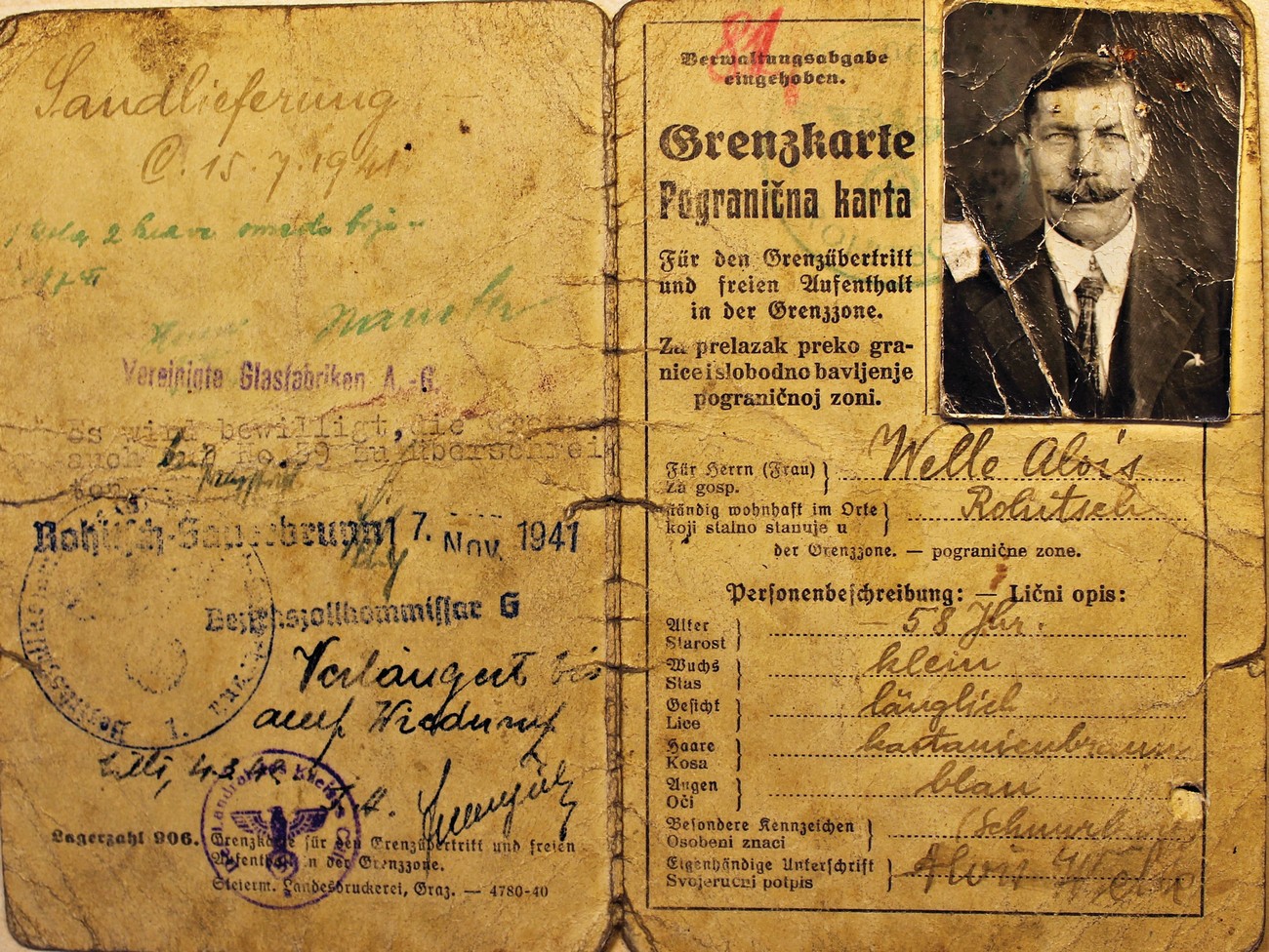
Example of a bilingual border pass (Grenzkarte) owned by Alojz Welle from Rogatec. In addition to the official stamp of the district customs office, and the date of issue and validity, each permit also contained a description of its owner with information on age, occupation and place of employment. There was a space for a photograph in the top right corner. Archives of the RS.
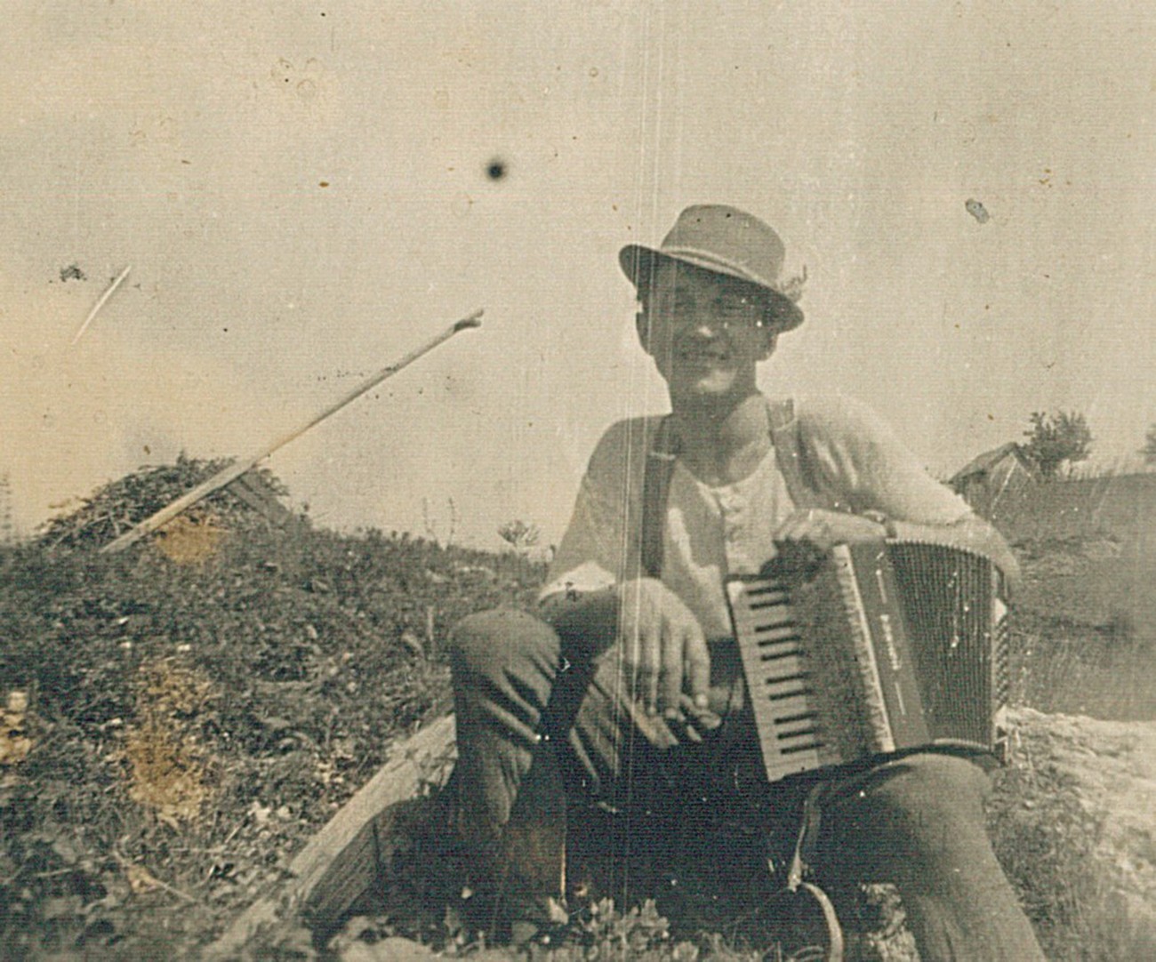
Franc Mikša – Maganatov Francl (in the above picture) lived right next to the Sotla River on the Croatian side of the border. On Easter Sunday in 1944, he was illegally crossing the border using his regular and well-trodden secret passage. He stepped on a newly planted landmine, which caused severe injuries. He spent the next three days dying at his home; in that time, they managed to write down his will. Source: personal archive of Branko Mikša.
The Sotla River is still the boundary river between the Republic of Slovenia and the Republic of Croatia. From 1941 to 1945 it was the boundary river between the German Reich and the NDH. In late 1941, the Germans guarded it heavily, enclosing it with barbed wire and minefields. Despite that, people soon started smuggling across it. The goods in high demand were sugar, tobacco, vitriol, salt, meat, fat, flour, eggs and even livestock. The photograph published courtesy of Božo Kolar (who owns the original) depicts the trading of goods at the Sotla River in the immediate vicinity of Rogaška Slatina, most likely in the summer of 1944.
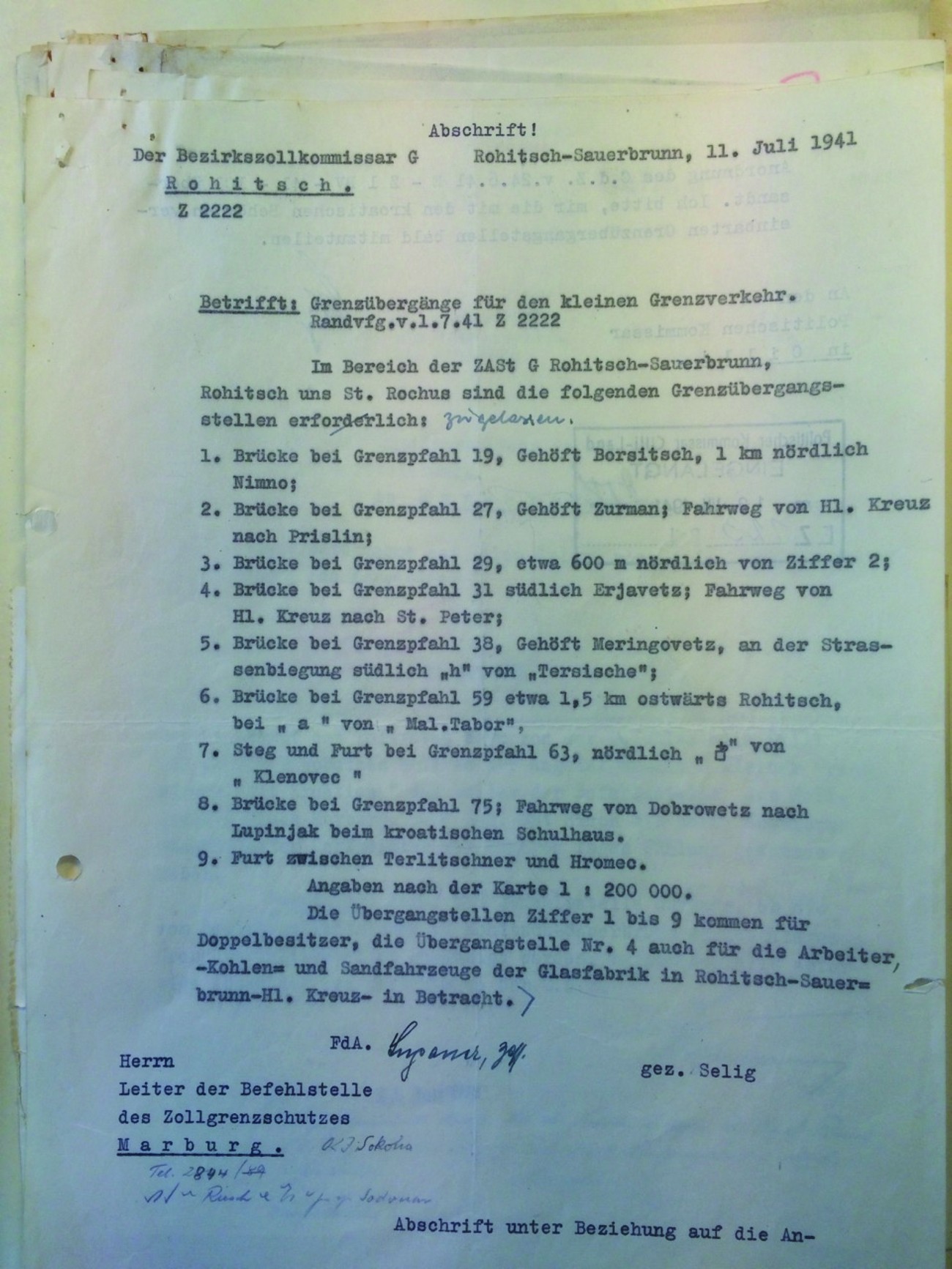
A report from the Rogatec District Customs Office regarding the border crossings for local border traffic in the sector between Rogaška Slatina, Rogatec and Sveti Rok. In the agreement reached on 11 July 1941 in Rogaška Slatina, they established 9 points for the legal crossing of the German-Croatian border. Archives of the RS.
A German watchtower on the border with the Third Reich. MNZS.